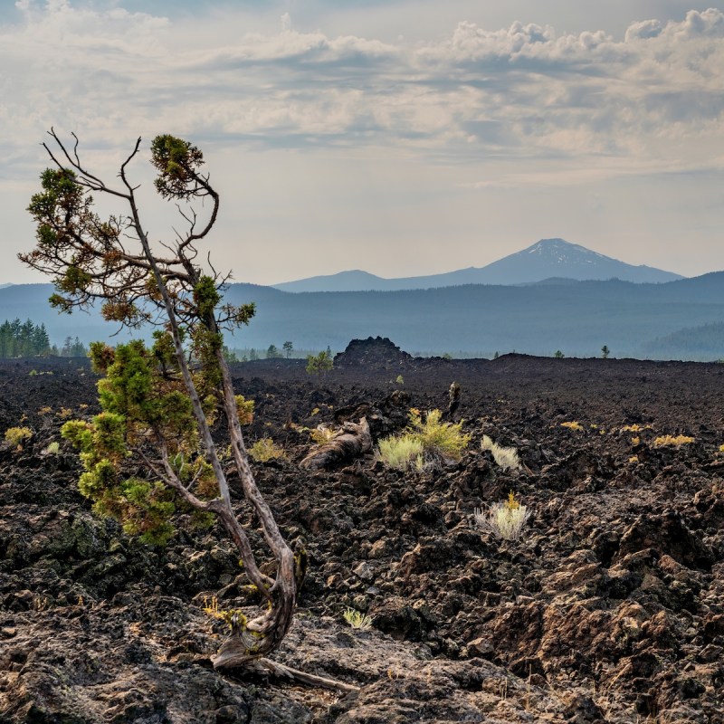
Oregon lays claim to only one volcanic national park — Crater Lake National Park. However, its lesser-known sibling — Newberry National Volcanic Monument — offers visitors an opportunity to see the Pacific Northwest’s largest volcano, without Crater Lake’s often congested parking lots and crowded trailheads. This immense volcano, encompassing over 1,200 square miles (about the size of Rhode Island), is located along a major highway but is virtually unknown; even to many Oregon residents.
Videos by TravelAwaits
Begin your volcanic adventure at Lava Lands Visitor Center (8 miles south of Bend), Central Oregon’s thriving outdoor activity and tourist hub. Lava Lands is open May through mid-October and provides visitors an entrée into the monument’s many sights and activities.
During my career as a park ranger, I had the pleasure of working at Newberry and would like to share some of my favorite places and things to do when visiting this unusual national monument.
1. Lava Butte
This cinder cone is a distinctive feature of the monument. Rising above the surrounding landscape, Lava Butte is one of over 400 cinder cones dotting the flanks of Newberry.
The eruption of this cone, around 7,000 years ago, sprayed a fiery blast of cinders (like a suddenly opened soda bottle) into a 500-foot pile around the vent in a remarkable display of natural fireworks. After this initial blast, a thick flow of 2,000-degree F lava (picture oatmeal flowing across your kitchen table) oozed out from the base of the cinder pile and covered an area over 20 miles long and 2 miles wide. This flow blocked the nearby Deschutes River and created a spectacular waterfall known as Benham Falls.
From May to mid-September, you can ride a shuttle bus to the summit of Lava Butte for a panoramic view of the high desert to the east and several lofty volcanoes stretching out across the western horizon. At the summit is a short trail around the rim and a small visitor information building that interprets the monument’s natural history.
Fun Fact: Lava Butte initially erupted black cinders, but later, due to rapid oxidation, some of the cinders turned red.

2. Newberry Crater
Yet another remarkable feature of Newberry Volcano is driving on a paved road across the crater (technically a caldera or collapsed mountain top) of an active volcano. Sound exciting? When the volcano erupted 75,000 years ago, it caused the summit to collapse inward creating a 4-mile-wide depression. Over time, rain and snow melt partially filled the depression to form two lakes — Paulina Lake and East Lake. The drive across this crater leads to several trailheads and to the 100-foot-high edge of Newberry’s most recent eruption — the 1,300-year-old Big Obsidian Flow.
Pro Tip: For those geology junkies in the crowd, a more comprehensive explanation of Newberry’s complex and volcanic history is found at the United States Geological Survey’s website.
3. Paulina Peak
At an elevation of 7,985 feet, the highest point in the national monument, Paulina Peak offers a spectacular view of central Oregon and, on a clear day, the opportunity to see over 100 miles and spot seven towering, stratovolcanoes in the Cascade Range. The road to the summit is unpaved, so take your time, drive carefully, and enjoy this breathtaking viewpoint.
4. Lava River Cave
If you are a cave person, you will want to explore Lava River Cave. It is Oregon’s longest lava tube and the first to be extensively explored. The lava tube is the result of an eruption of sticky basalt lava that spread out, piled up, and as it cooled, formed a thick crust while leaving the interior still molten. As the hot lava drained out, it left a hollow tube behind. Today, that tube is a mile-long cave that takes you into an underground world totally devoid of light. Here, the once molten rock dripped from the cave’s ceiling and left hardened “lavacicles” and horizontal layers on the cave walls from different pulses of lava flowing over time. Look closely with your light and you may see strange insects that live in this eternal darkness.
The cave has about 150 steps to reach the bottom and the hike inside is on uneven surfaces, so be prepared with sturdy shoes and carry at least two, dependable light sources. The cave maintains a constant 42 degrees year-round, so bring layered clothing.
Pro Tip: If you have never experienced total darkness, stop along the way, turn off your light for a minute, and experience this peculiar sensation. When I was a ranger at Newberry, I led cave tours and discovered that this simple exercise often evokes sudden silence. Be prepared for an out-of-the-ordinary sensation.
5. Lava Cast Forest
A thousand years before Lava Butte erupted, a similar eruption produced a stream of thick lava that slowly moved across the land. As the lava flowed through a mature forest, it burned the trees and generated steam from water in them, which cooled the lava just enough to create hollow molds of the trees.
A 1-mile paved trail, with interpretive signs to help you understand its formation, meanders among this ancient forest, where the tree molds tell a story of the fiery process that enveloped them in this ancient inferno.
Pro Tip: The 10-mile road leading to this site is not paved and can be rough in places. Drive carefully and plan on a 30–40 minute trip from Highway 97.

6. Hiking And Camping
Within the monument’s 54,000 acres is a wide assortment of trails for your hiking and biking pleasure. Campgrounds are scattered throughout the monument and the surrounding Deschutes National Forest. I’ll highlight a few trails and my all-time favorite campground.
Trail Of The Molten Lands
A paved trail begins at the Lava Lands Visitor Center at the base of Lava Butte. This 1-mile, partially accessible loop takes you on an easy stroll across the craggy surface of an old lava flow. For some visitors, a walk on the once molten rock could very well be one of your most unusual bucket-list items. While working at the visitor center, I walked this trail dozens of times and saw something I hadn’t noticed before each time.
The Big Obsidian Trail
This trail begins near the foot of an obsidian flow; formerly molten, volcanic glass that surged out of the side of the volcano, piled up, and cooled into a 1-square-mile heap of sparkling chunks of glassy lava. The 1-mile trail is located inside Newberry Crater and takes you up and over this crusty flow. Be sure to wear sturdy shoes or boots as the obsidian chunks can be sharp and uneven along the route.
Paulina Lakeshore Loop
For another crater hike, try this 7.3-mile loop along the shore of the deep, clear Paulina Lake. The trail is dirt and often rocky with a 430-foot switchback up a cinder slope for a stunning view of the lake. The hike takes 2–3 hours depending on your pace.
Benham Falls Trail
Begin at the Benham Falls East trailhead for this easy 2-mile round-trip hike to the viewpoint at the falls. Along the way, you will follow the Deschutes River and see the lava flow that emerged from Lava Butte and briefly dammed the river.
Little Crater Campground
This is a great campground centrally located in Newberry Crater. The majority of the 49 sites must be reserved through Recreation.Gov but, for those willing to gamble, there is a scattering of first come, first served sites. I spoke with Heidi and Andy who were visiting Newberry for the first time and found an unreserved campsite: “We just drove up and decided to see if we could find a site without a reservation and wow, we did!”
7. Mountain Biking Trails
Crater Rim Bike Trail
This is a challenging yet enjoyable 22-mile bike trail around the rim of Newberry Crater. You will be rewarded for your efforts with stunning views of the entire 20-square-mile crater, including the Big Obsidian Flow and Paulina and East Lakes. Be prepared for some rough spots and bring plenty of water and layered clothing. Allow 4–6 hours to complete the loop.
Pro Tip: Skilled bikers recommend riding in a counterclockwise manner to avoid steep switchback climbing along the trail.
Peter Skene Ogden Trail
This is a serious, uphill ride packed with the thrill of seeing over a dozen waterfalls along the way. Begin your trek (uphill only) at McKay Crossing Campground and top out at 6,300 feet at Paulina Lake inside Newberry Crater. The downhill portion is a swift ride on a paved road back to the campground. It is classified as intermediate and a great ride amid forest and volcanic landscapes. For a longer ride, begin at the Ogden Group Camp downstream from McKay Campground. The ride is between 12 and 18 miles round-trip depending on where you begin. Always check the monument website for current conditions on this and other trails before beginning your adventure.
Sun Path Trail
For a less strenuous ride, or walk, try this paved and mostly flat, 4-mile trail that begins at the Lava Lands Visitor Center and takes you through a tranquil Ponderosa pine forest. A portion of the trail skirts the edge of the large lava flow from the eruption of Lava Butte so you can get up close with this gigantic volcanic feature. The trail ends at a scenic overlook at Benham Falls on the Deschutes River.
Pro Tip: Shoulder seasons (before Memorial Day and after Labor Day) are a good time to plan your monument visit. Crowds at viewpoints and trailheads thin out and it’s cooler than during the typical hot, summer months. Check the website for specific information on weather and road/trail conditions.
These are just a few of the monument’s many enjoyable adventures. Be prepared, stay safe, and enjoy Newberry’s natural beauty and geological wonders.