(Klara_Steffkova / Shutterstock.com)
I first traveled the famous Icefields Parkway in Alberta, Canada, when I was less than a year old. My parents loaded up their navy Volkswagen Beetle, stowed me in the back seat (I’m not even certain a car seat was involved back in the day), and set off for an adventure to Jasper National Park. Fast forward numerous decades and I finally made it back to the park, this time with my own kids along for the ride.
If anyone wonders how much I adore this park, they need only look at our Bernese mountain dog, Jasper. He’s a daily reminder of this rugged wilderness paradise, to which, I often say, I will happily move when I retire. There are countless more hikes beyond those listed here that call to me, as well as lakes, waterfalls, meadows, and wildlife to explore and admire.
If your own travels are taking you to Alberta, consider these top five hikes in Jasper National Park at the northern tip of the Icefields Parkway. They range from relatively flat and easy to more heart-pounding, but incredibly rewarding. Happy hiking!

(Photo Credit: Michelle Peters)
1. Edith Cavell Meadows
- Location: Highway 93A to Cavell Road
- Length: 5.1 miles (loop)
- Elevation change: 1,879 feet
- Difficulty: Moderate
The dominating, 10,826-foot-high Mount Edith Cavell loomed over our family’s unanimous favorite hike during our time in Jasper National Park: Edith Cavell Meadows. At the time, there was roadwork occurring on the old parkway up to the hiking trail and the day-use parking area, so a special permit was required to access the hike.
This meant a 6 a.m. wake-up for one of the adults, followed by a 1-hour wait in town until the park office opened while crossing your fingers that you’d be issued a pass for that afternoon. Otherwise, you’d be trying again the next day. Thankfully, I got there in plenty of time, got the pass, and was even able to stop into the Jasper Bear’s Paw Bakery across the town square to bring flaky pastries and coffee back to my awaiting family at the campground. (Do not miss this local bakery for its savory breakfast sandwiches, sweet treats, freshly baked bread, cookies … I could go on and on!)
Today, the construction work is complete, and you may drive up to the trailhead whenever you please (although, with most longer day hikes, I would advise going as early as possible during the day to avoid the crowds and midday heat).
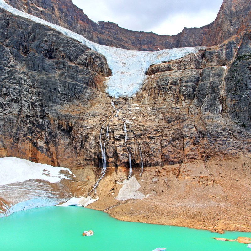
As you approach the final section of the twisting, turning Cavell Road, you’ll feel, then see, the presence of the mighty mountain, rising above the lush, sub-alpine forests. Lace up your boots and get right into it as you first tackle the partially paved Path of the Glacier Trail. The amazing views overlooking the Angel Glacier and Cavell Pond are just a teaser of what’s to come. Look for icebergs that have calved into Cavell Pond and gaze at Angel Glacier across the way, where it rests in a cirque between Mount Edith Cavell and Sorrow Peak. What was staggering to us was how close everything felt, like you could practically reach out and touch the glacier.

(Photo Credit: Michelle Peters)
Continue on the Edith Cavell Meadows Trail, climbing uphill through a rocky moraine (look for pikas and hoary marmots peeking out from between the rocks), through the forest, and then up into a beautiful, wildflower-strewn meadow above the treeline. The views of the glacier and the mountains around you are consistent throughout the hike, making this a particularly gratifying trek for anyone with a quickly bored teenager.

(Photo Credit: Michelle Peters)
Bring along an extra layer or two, which you’ll want as you approach the colder, windier apex of the hike. Just before you reach the main lookout area at the end of the trail, you’ll see a junction with two options, which can be completed as a loop.
If you’re short on time, consider just hiking the Path of the Glacier Trail from the parking area. It’s just under a mile round trip with a 229-foot elevation gain and takes about an hour to complete.

(Photo Credit: Michelle Peters)
2. Sulphur Skyline Trail
- Location: Miette Hot Springs parking lot
- Length: 4.9 miles (out and back)
- Elevation change: 2,142 feet
- Difficulty: Moderate/Challenging
This signature Jasper National Park hike is worth all the effort it entails once you’re back at the trailhead, soaking your weary muscles in the Miette Hot Springs. We had our then-elementary-school-aged kiddos in tow for this one and got a sideways glance from the park ranger the night before when we mentioned we had this hike in our sights for the next day. With the promise of good snacks and the hot springs at the finish line, we set off early, hiking steadily uphill for the first 1.2 miles. This section of the trail doesn’t boast many views, so it’s a bit of a head-down grind until you emerge to vistas across the valleys to rugged ridges in the distance. After a break, continue up the switchbacks until the treeline. Look down into the Fiddle Valley, then push on to the summit. From the top, you’ll spin around like Maria von Trapp, drinking in the 360-degree alpine panoramas, from Utopia Mountain to the Ashlar Ridge.
As promised, we hit the Miette Hot Springs at the end of the day. These natural hot springs produce the hottest mineral water in the Canadian Rockies at 129 degrees Fahrenheit and are cooled to a comfortable temperature of 104 degrees — the perfect antidote for our taxed legs. As for that park ranger who seemed to have her doubts about our kids’ ability to tackle Sulphur Skyline? We ran into her that night at a campground ranger event and the kids proudly told her what they had accomplished. Needless to say, she was impressed and went on to tell us of her various treks within the park, suggesting some for our next trip.

(Edwin Christopher / Shutterstock.com)
3. The Whistlers Trail
- Location: Just west of the town of Jasper
- Distance: 10.3 miles (out and back) / 2.3 miles (out and back) if taking SkyTram
- Elevation change: 4,324 feet / 895 feet from SkyTram station
- Difficulty: Challenging / Easy if taking SkyTram
There are two options for ascending Whistlers Peak, depending on your time availability and energy level. No one will judge you if you take the first option, which is to ride the scenic Jasper SkyTram to the near-summit, then hike 30 to 45 more minutes to the true top (this is what we did). It’s a very accessible and rewarding trail, with the chance to sit for a spell in one of the park’s iconic red Adirondack chairs at the peak. Look (and listen) for the whistling marmots, but as the rangers will be quick to tell you, please do not approach or feed them.

(Photo Credit: Michelle Peters)
If you have more time and are seeking a longer trek, consider skipping the tram and tackling the full 10.3-mile, out-and-back trail (plan on 6 to 7 hours for the whole endeavor). The trail is nicely marked and the switchbacks are well maintained. Above the summit restaurant, enter a section of boulders, a fun and challenging stretch, and one that affords you nice views of the top of the mountain. The final section is steep, re-entering some forest before zigzagging its way to the tippy top.

(Ivan_Yim / Shutterstock.com)
4. Maligne Canyon Loop
- Location: 10 minutes outside the town of Jasper
- Distance: 2.3 miles (loop)
- Elevation change: 429 feet
- Difficulty: Easy
Geology buffs won’t want to miss this loop trail outside the town of Jasper. Plan on just over an hour to hike the trail and appreciate the waterfalls, fossils, raven and black swift nests, lush plant life, and churning water of the Maligne Canyon. The canyon is carved into the Palliser Foundation, a layer of limestone that was deposited in a shallow sea by plankton some 365 million years ago. It’s just 6.5 feet across in places and has a depth of up to 164 feet. Take note of the Parks Canada signs along the self-guided interpretive trail, providing more geological history about the area.
Arrive early to beat the summertime crowds. Several bridges, aptly named First Bridge through Sixth Bridge, offer incredible viewpoints of the canyon. The inclines are gentle and there are no difficult or steep sections. For an extra-special view, go past the Sixth Bridge and continue on the Seven Path. Turn right to find a half-hidden, mini beach area next to the water. Rest on the bench and take in the marvelous views of the Canadian Rockies reflected in the water.

(Petr Kahanek / Shutterstock.com)
5. Bald Hills Trail Loop
- Location: Maligne Lake area
- Distance: 9.3 miles (loop)
- Elevation change: 2,559 feet
- Difficulty: Moderate/Challenging
If you hike for the views (I know I do!), the Bald Hills Trail Loop hike is a must. This legendary Jasper outing will take you high above the tree line for far-reaching vistas of, well, the Bald Hills, plus numerous other summits. The drive alone is noteworthy — you’ll want to pull over and take photos, but just use caution because the road can get busy in the summer months. This is a good choice if you’re already in the Maligne Lake area (tip: tack on a lake cruise before or after your hike).
Follow the gravel fire road for some time, before it narrows and becomes more of a hiking trail. You’ll eventually come to a junction, from which both paths ultimately lead to the summit. Go left for a more direct, steeper, shorter ascent, or go right to remain on the more gradual, gravel path. (If you have cranky knees, I suggest taking the shorter route on the way up and the longer route on the way down.)
The paths meet above the treeline at the edge of an alpine meadow, from which you can clearly see one of the Bald Hills and the steep switchbacks that zigzag up to the summit. From the barren alpine field at the top, you can see Maligne Lake below you, and Leah Peak, Samson Peak, and Maligne Mountain across from you, with their glaciers glinting in the sun. It’s chillier up here and windy, so pack a warm coat and/or windbreaker. If you care to go farther, you can continue along the path to the next peak for more stunning views of a secluded valley, sheer rock faces, and Trowel and Evelynn peaks.
Pro Tip: As for most national parks, the summer — while often boasting the best weather — is the most crowded time to visit. Daytime temps are around 70 degrees, nighttime lows around 45 degrees. Aim to get to the trailhead as early as possible in the day. Consider visiting during the “off” seasons: March through May and September through November. During these times, the highs are closer to 60 degrees, with lows around 20 degrees.
As always, writing about my travel adventures relights the flame and has me researching more and better hikes in my beloved Pacific Northwest and beyond. Please remember, when enjoying the great outdoors, pack the Ten Essentials, respect the environment, pack out your trash, and leave the wildlife to itself.
