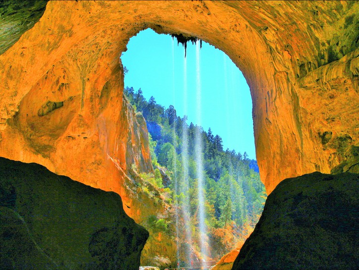
A number of man-made bridges throughout the world have become tourist attractions, but it is a bridge carved by nature that merits an almost two hour drive from Phoenix, Arizona. Believed to be the largest travertine bridge in the world, Tonto Natural Bridge sits in a tiny valley surrounded by pine trees. The bridge stands 183 feet high over a 400-foot tunnel that measures 150 feet at its widest point.
Mother Nature sculpted Tonto Natural Bridge over thousands of years as precipitation seeping underground through layers of tilted, faulted, and eroded rock collected and deposited calcium carbonate to create a travertine dam. Water eroded through the travertine and eventually formed the bridge.

Travertine is a terrestrial sedimentary rock created by spring water rich with carbon dioxide filtering through limestone. The water becomes saturated with calcium carbonate dissolved from the limestone. When it hits the air, carbon dioxide is released and the calcium carbonate crystallizes. Pure travertine is white, but it is frequently found in shades ranging from yellow to brown due to the presence of other carbonate minerals.
Discovery
The discovery of Tonto Natural Bridge in Pine Creek Valley was first documented in 1877 by prospector David Gowan. He claimed squatter’s rights and laid claim to the land. Eventually he passed possession to his nephew, who established residence in 1897. Twenty years later, that nephew filed a homestead claim. He owned the land until 1948.
The Arizona State Parks Board was created in 1957 and had an interest in the Tonto Natural Bridge property almost since its inception. But it was not until 1990 that the Board acquired the property from its legal owners of that time. Tonto Natural Bridge State Park officially opened June 29, 1991.
Trails and Viewing
Visitors can view the bridge from atop it at any of four parking lot viewpoints. But, if you are able, hike down to the bottom to gain a fuller appreciation of the majesty and beauty of the bridge.
Two trails take you under the bridge from different directions. Four hundred feet of the half-mile-long Pine Creek Trail is developed. You climb your way over rocks in the undeveloped portion in the creek bed while arrows painted on rocks point you in the right direction. The popular Gowan Trail is a bit under a half-mile long and leads to an observation deck in the creek bottom. Whichever trail you choose, wear good shoes with grip. Both trails are steep and the rocks can be wet and slippery, but you’ll be rewarded with amazing views of rock formations around you and of the bridge. The Park suggests allowing an hour for each trail.

Tonto Natural Bridge.
Both trails end at the bridge, at which point you can turn around and head back to the parking lot. If the water under the bridge is not too high and you feel brave and agile enough, you can continue under the bridge to connect with the other trail. You’ll have to climb up and down past large, slippery boulders to do so. Note that swimming and wading is not allowed in the small pools of water under the bridge. There are spots further upstream and downstream from the bridge where you can play in the water.
A third trail, the 300-foot-long Waterfall Trail, takes you down to a waterfall cave instead of under the bridge. Again the trail is steep with uneven steps, but only fifteen to twenty minutes are needed to hike it.
You’ll see more than rocks on these trails. Vegetation includes cacti, oak trees, pinyon pines, juniper, alder trees, silk tassel shrubs and sumac. Picnic tables are located throughout the park.
Visitor Center
The Visitor Center and the Park Store, which sells books about the area, T-shirts, snacks, water, and walking sticks, are located in the historic Goodfellow Lodge. Interpretive exhibits inside the Lodge contain information about the history of the bridge, travertine, prehistoric inhabitants, and the Lodge itself. The three-story, cabin-style, rustic lodge was built in 1927. It has ten bedrooms with communal bathrooms and is available for groups to reserve.
Tonto Natural Bridge State Park is located 100 miles northeast of Phoenix, ten miles north of Payson. The Park is open daily year round.
Each season offers a unique experience, but the best time to visit may be spring or fall. Weather in spring and fall is moderate. Spring brings blossoms to the trees and fall turns the leaves into a blaze of colors. Winter can be cool and there may be snow, although it melts quickly. Summer temperatures average in the mid-90s Fahrenheit and can reach 100. Thunderstorms can drop inches of rain in short periods of time.
Check weather conditions before you go. Also confirm current hours with the Park as they vary seasonally.
Happy trails!
