
Note: The Travel Awaits team regularly updates content to provide the latest, and most accurate information to our readers. The updated content in this article may not reflect the views or opinions of the original author.
Videos by TravelAwaits
Home to the world-famous Grand Canyon, one of the best-known natural wonders of the world, Arizona showcases some of the most dramatic scenery in the country. The much-photographed Monument Valley, volcanic fields, and gorgeous rock formations highlight different stages of Earth’s geology.
In stark contrast with the barren rocks, the Sonoran Desert, home of the giant saguaro, tells a different story — a story of survival in a waterless area, defying visions of the desert as a dry and sand-filled land.
In the center of the state is a transition zone, with deciduous and pine forests and more lakes and reservoirs than you would expect.
Scenic drives offer the opportunity to experience some of Arizona’s varied topography and dramatic landscapes. You can find these drives in every corner of the state, and they feature everything from lava flows and cactus gardens to canyon rims, mesa tops, and pine forests. The following are only a few of the drives you can take to experience the gorgeous landscape of Arizona.
9 Most Amazing Scenic Drives In Arizona
1. Grand Canyon South Rim Scenic Drive

Showcasing the world-famous Grand Canyon, the 57-mile South Rim Drive starts in Cameron, just off Interstate 89 North, and runs through Grand Canyon National Park. Running along the Little Colorado River Gorge, the road offers opportunities to stop at two overlooks.
Inside the Grand Canyon National Park, Desert View is your first stop, where you can walk up to the Lookout Tower, enjoying the Native American art on its walls and gorgeous views of the canyon, including the Colorado River at the bottom. Next, you’ll have the opportunity to stop at all the viewpoints, or park at the Main Visitor Center and explore the rim of the trails. Then keep driving to Grand Canyon Village, the park’s headquarters. Here, you’ll find all the park’s amenities, including dining and lodging choices.
The drive is open year-round, though it gets extremely busy in the summer, especially on weekends. The best times to visit are the shoulder seasons. Winter gets cold, but it offers an opportunity to visit without the crowds.
Explore hotels and Airbnbs near Grand Canyon South Rim Scenic Drive
Note: Located in the Native American Navajo Nation, the road from Cameron to Desert View was closed at the time of my visit currently closed. I could still drive it in the opposite direction, from Grand Canyon Village to Desert View. Watch the advisories to see when the rest of the stretch will open.
2. Sedona To Oak Creek Canyon Scenic Drive

This 27-mile scenic road connects the ponderosa-pine-filled high country of Arizona in Flagstaff with the red rock country of Sedona, following the narrow and spectacular Oak Creek Canyon.
The scenic road, Interstate 89A, starts 2 miles south of Flagstaff at Exit 337 off of Interstate 17 South and heads through a ponderosa pine forest. Make sure you stop at Oak Creek Vista Point for gorgeous views of Oak Creek Canyon. From here, the road follows steep switchbacks down to the canyon floor and continues along the creek. Here, you’ll find two campgrounds and day-use areas with picnic tables, if you wish to stop.
Halfway through the canyon, you’ll reach Slide Rock State Park, one of the most popular swimming areas in the state, where the creek rushing through the slippery rocks creates a natural waterslide.
The scenic drive ends in Sedona, known as one of the most beautiful small towns in the United States, filled with art boutiques and surrounded by gorgeous red rock formations.
This scenic road gets very busy during the summer months, especially on weekends. Campgrounds in Oak Creek Canyon are first come, first served, so if you’d like to camp, make sure you get there early. If you’re trying to get to Slide Rock, avoid weekends and go early.
Explore hotels and Airbnbs near Sedona To Oak Creek Canyon Scenic Drive
3. Apache Trail Scenic Drive

A National Scenic Byway, the Apache Trail crosses the rugged northern part of the Superstition Mountains just northeast of Phoenix, offering access to three reservoirs and gorgeous desert scenery.
Named for the Apache people who once used this trail, the road winds through canyons and mountain ridges, offering plenty of pull-outs where you can enjoy the surroundings. It starts at the Goldfield Ghost Town, goes to Lost Dutchman State Park, and then heads north and passes Needle Vista, with gorgeous views of the Superstition Wilderness.
You’ll drive through hills filled with giant saguaros, with several scenic stops where you have the opportunity to enjoy the gorgeous scenery or take a hike through the cactus-filled desert. Eventually, the road descends to Canyon Lake, with opportunities to stop and enjoy the narrow reservoir surrounded by towering rocks.
Past it, you’ll reach Tortilla Flat, the only “community” there (with a population of six people), home to a cafe and gift shop. Tortilla Flat is the end of the road at this time. A few miles past it, the road is closed due to extensive road damage caused by the Woodbury Fire in 2019. However, even just to Tortilla Flat, the road is still one of the most scenic ones in the state.
Explore hotels and Airbnbs near Apache Trail Scenic Drive
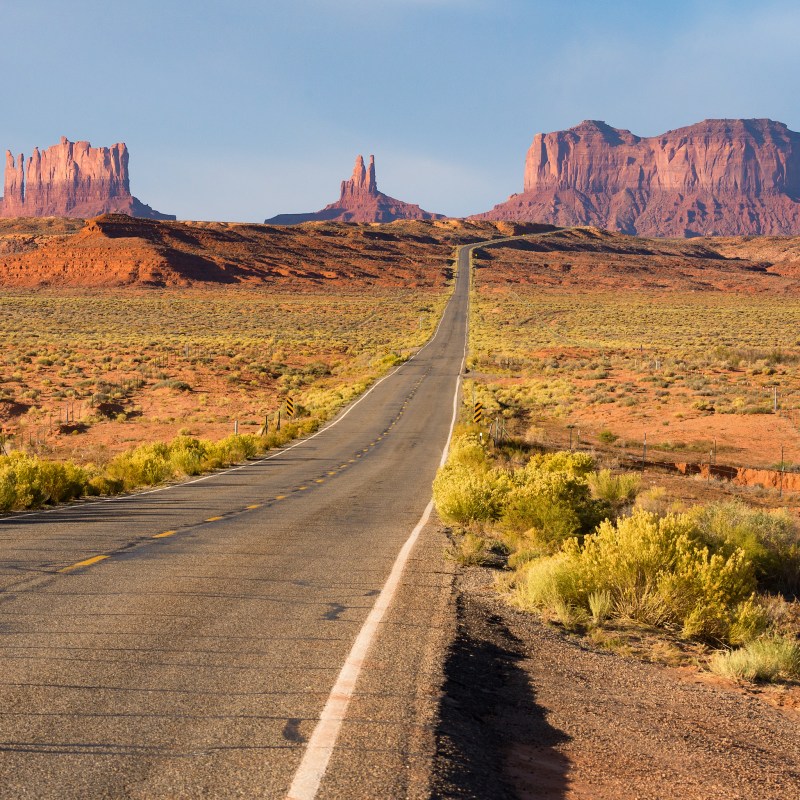
4. Kayenta To Monument Valley Scenic Drive

The best-known and most-photographed scenic road in the Southwest, featured in movies like Forrest Gump, this stretch of road through the Navajo Nation is a visual experience you’ll never forget. The rough, barren land, with its sparse vegetation, showcases some of the best geological features of our planet. The sandstone in all shades of rust, orange, purple, and red, eroded into surreal forms, is striking.
The 22-mile stretch of U.S. 163 runs from Kayenta to the Monument Valley turnoff, passes into Utah for a few miles, and then returns to Monument Valley in Arizona.
Along the way, you’ll drive through mesas and ridges, cross the deep Laguna Creek, and drive by Comb Ridge. One of the most striking features of this landscape is the sharp peak of Agathlan, a large volcanic rock formation visible for miles.
But nothing compares to the first view of the vast Monument Valley, filled with rock formations of all shapes and sizes rising 400 to 1,000 feet from the flat surface.
Explore hotels and Airbnbs near Kayenta To Monument Valley Scenic Drive
Note: Since this road is fully on the Navajo Nation’s territory, please check the Monument Valley home page for updates.
5. Sky Island Scenic Byway

This 25-mile paved National Forest Scenic Byway, one of Arizona’s most beautiful drives, ascends the 9,157-foot Mount Lemmon in the rugged Santa Catalina Mountains north of Tucson. The road travels from the saguaro-filled Sonoran Desert to the fir-filled summit, offering scenic views with plenty of camping and picnicking opportunities.
One of Arizona’s “sky islands,” the mountains tower above the surrounding environment, offering a refuge from the desert heat. Temperatures drop as much as 25 degrees from the bottom of the mountain to the end of the road.
You’ll find plenty of scenic overlooks; Windy Point is considered one of the best. Higher up, you’ll enter the pine forest, a much cooler zone where you’ll find plenty of hiking trails, picnic areas, and campgrounds. The road ends at Summerhaven, but just 2 miles before reaching the rustic village, you can turn toward the ski area, where you can take a trail to the summit of Mount Lemmon.
The road is open year-round, though the highest areas might be closed during the winter. It’s popular during the summer, when you should avoid visiting on weekends, if possible.
Explore hotels and Airbnbs near Sky Island Scenic Byway
6. Willcox To Chiricahua Scenic Drive

This 42-mile road takes you along the southern edge of the Dos Cabezas Mountains before climbing up Bonita Canyon to the scenic Massai Point at the Chiricahua National Monument. The scenic byway, following Arizona Highways 186 and 181, passes through the shrub- and cacti-filled landscape of the Upper Sonoran Desert to fir and pine forests at the highest elevations.
But you’ll find the best scenery in the unique and remote Chiricahua Mountains, filled with towering rock formations. Massai Point, the end of the road, is the climax of this drive, home to the area aptly nicknamed the “Wonderland of Rocks.”
The road is open year-round, though it’s best experienced during the shoulder seasons since summers tend to get hot, and during the winter, parts of the road may be closed due to snow.
Services are available in Wilcox, but none farther on. You’ll find campgrounds in Coronado National Forest and at the Chiricahua National Monument.
Explore hotels and Airbnbs near Willcox To Chiricahua Scenic Drive
7. Fredonia-Vermillion Cliffs Scenic Road

The Fredonia-Vermillion Cliffs Scenic Road takes you on U.S. 89A from Fredonia to the junction with U.S. 89 south of Page. As you drive along the desolate road crossing the Kaibab Plateau, you are surrounded by gorgeous colored sandstone cliffs until you reach the Kaibab National Forest, filled with spruce, aspen, ponderosa pine, and juniper.
Past the forested area, you’ll travel along the foot of the Vermillion Cliffs rising from the Paria Plateau, my favorite stretch of this road. Though mostly devoid of vegetation, the cliffs offer the most picturesque backdrop for the road; their shapes and changing colors of all shades of red offer a feast for the eyes.
Then you reach the Navajo Bridge, spanning across the gorgeous Marble Canyon and the Colorado River below. This is one of our favorite places to stop along this route, to enjoy the surrounding landscape, and, when open, step inside the interpretive center and bookstore run by the Navajo Nation.
Past the Navajo Bridge, the route turns south along the foot of the Echo Cliffs and ends at the junction with U.S. 89 at Bitter Springs.
Explore hotels and Airbnbs near Fredonia-Vermillion Cliffs Scenic Road
8. Red Rock Scenic Byway
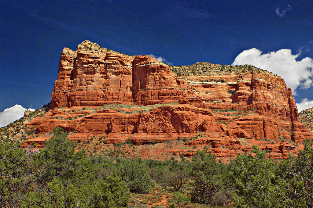
Red Rock Scenic Byway, often called a “ museum without walls, is only 14.5 miles long scenic road, but the drive itself is stunning. The layered pattern in the red rock features along the way is best observed at Cathedral Rock, a cliff-like red rock formation, popular with hikers and spiritualists.
Apart from the desert viewpoints and rock landmarks, there are also fun things to stop and see like the Tlaquepaque Arts & Shopping Village, the walkable shopping district. However, the Chapel of the Holy Cross, which offers breathtaking views of the landscape from high above, is the ultimate bucket list item on the Red Rock Scenic Byway route.
Explore hotels and Airbnbs near Red Rock Scenic Byway
9. Petrified Forest Scenic Road

The colorful Petrified Forest Road bisects the Petrified Forest National Park which is of interest primarily due to the forest of extinct ancient trees that produce an awe-inspiring display of color and shape. The park is some 26 miles east of the old mining town of Holbrook. Consider this town a place of interest for the errant fossil hunter and gem collector.
Honorable mention to other Arizona attractions goes to Joshua Forest Scenic Road, Goldfield Ghost Town, Window Rock Tribal Park, and Lake Powell.
Whichever road trip you choose, Arizona’s scenic drives unveil a stunning tapestry of landscapes. Embark on a memorable journey through the iconic red rocks of Sedona, drive past the otherworldly landscapes of Monument Valley, and marvel at the vastness of the Grand Canyon. Witness the Sonoran Desert’s saguaro cacti, and explore the historic Route 66. You will remember this road trip for decades to come.
Explore hotels and Airbnbs near Petrified Forest Scenic Road
FAQs
What Is the Most Scenic Road in Arizona?
It would be hard to put a finger on the most scenic road in Arizona as there are too many really. Whether it is the Apache Trail, Historic Route 66, or the gorgeous Red Rock State Park, there are tons of beautiful views a quick road trip away.
What Are the Benefits of Exploring Arizona by Car?
Taking a scenic road trip in Arizona allows you to connect with nature on a deeper level. Driving on a scenic road allows you to stop whenever and wherever you please to enjoy the stunning landscapes and capture picture-perfect moments.
What Is The Most Popular Forest Scenic Road in Arizona?
Petrified Forest National Park is probably the most popular one, while the honorable mentions go to Joshua Forest Scenic Road, Coconino National Forest, Prescott National Forest, and the Apache Sitgreaves National Forest.
What Part of the Grand Canyon Should I Visit?
Many travelers opt to visit the South Rim, which is home to several hiking trails, including popular routes like Bright Angel Trail and Rim Trail. For a less crowded alternative, try visiting the North Rim between May and October.
What Are the Most Popular Arizona State Parks for a Road Trip?
Red Rock State Park, Roper Lake State Park, Patagonia Lake State Park, Lake Powell, and Lost Dutchman State Park are some of the famous State Parks in Arizona. Located in almost every region, Arizona State Parks are great for turnaround trips.